

Hiking in Berlin and the surrounding area
The most beautiful routes, from the city centre to Brandenburg
With extensive forests and waterways, Berlin offers numerous opportunities for local recreation in the city's natural surroundings. We would like to show you how you can discover the green side of the city on Berlin's hiking trails. Lace up your hiking boots and look forward to idyllic, interesting and surprising hikes in and around Berlin!
Havelhöhenwanderweg
Getting there and information about the Havelhöhenwanderweg:
- Bus | M49 (Stößenseebrücke)
- S-Bahn | S3, S9 (Pichelsberg)
- Start and finish: Heerstraße (Charlottenburg) – Strandbad Wannsee (Zehlendorf)
- Length: approx. 10 km
- Duration: approx. 4–5 hours
- Difficulty: easy
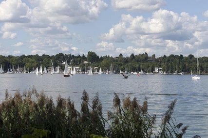
The Havelhöhenweg trail runs along the Havel river from Pichelsberg southwards through the Grunewald forest to the Wannsee lido. In addition to the scenic attractions, the 55-metre-high Grunewald Tower, the "Wald.Berlin.Klima" forest exhibition, the Schildhorn monument and the idyllic Havel island of Lindwerder are among the highlights of the hike. The Grunewald Tower has a viewing platform from which you can enjoy a beautiful view. At the end of the hike, you can relax and refresh yourself at the Wannsee lido.
Wuhletalweg
Getting there and information about the Wuhletal:
- Bus | 197, 390, 901, N97 (Ahrensfelde)
- S-Bahn | S7 (Ahrensfelde)
- Tram | 16, M8 (Ahrensfelde/city limits)
- Start and finish: Eichepark (Marzahn) – Köpenick S-Bahn station (Köpenick)
- Length: approx. 15 km
- Duration: approx. 4.5 hours
- Difficulty: easy
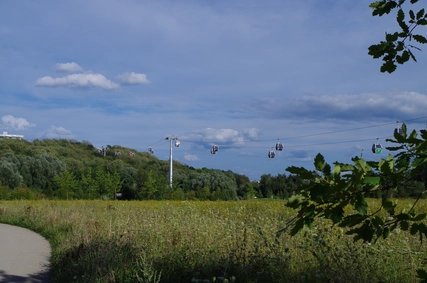
A half-day hike through nature in the middle of the city – that's what the Wuhletal hiking trail offers, winding its way from Eichepark at the Ahrensfelde S-Bahn station through the Wuhle valley to the south to the Köpenick S-Bahn station. The Wuhletal S-Bahn station, about halfway along the route, is a good starting or ending point for a partial stage. In addition to the species-rich, idyllic river valley itself, you will encounter numerous parks and meadows along the way. The route also runs along the IGA grounds, which invite you to take a short detour with a cable car ride .
Panke hiking trail

How to get there and information about the Panke hiking trail:
- S-Bahn | S2 (Bernau)
- Regional Express | RE3 (Bernau)
- Start and finish: Bernau S-Bahn station (Bernau near Berlin) – Reinickendorfer Straße underground station
- Length: approx. 26 km
- Duration: approx. 7–8 hours
- Difficulty: medium
From Bernau in Brandenburg, the Panke flows across north-east Berlin to almost the main station – a route that is somewhat challenging due to its length, but all the more interesting for it. You start in tranquil Bernau, outside the Berlin city limits, and then walk along changing panoramas to the city centre. Of course, you can also hike from the Spree towards Bernau or hike only part of the route. The Karow S-Bahn station halfway along the route is a good starting or ending point for this.
Tegeler Fließ

Getting there and information about the Tegeler Fließ:
- Bus | 222, N22 (Alt-Lübars)
- Start and finish: Alt-Lübars (Reinickendorf) – Tegel Palace
- Length: approx. 8 km
- Duration: approx. 2–3 hours
- Difficulty: medium
The hike takes you from idyllic Alt-Lübars, Berlin's oldest village, downstream along the Tegeler Fließ to Tegel Palace on Lake Tegel. Along the way, you will encounter numerous enchanting natural landscapes and wet meadows, such as the Lübarser Felder nature reserve, and even exotic water buffalo. Lake Hermsdorf, through which the Tegeler Fließ flows, is also on your route. At the end of the hike, you can take a stroll through Tegel Palace Park.
Schlachtensee

Getting there and information about Schlachtensee:
- S-Bahn | S1 (Schlachtensee)
- Start and finish: Schlachtensee S-Bahn station
- Length: approx. 6 km
- Duration: approx. 1–2 hours
- Difficulty: easy
On a walk around Schlachtensee in the south-west of the city, you can combine hiking in Berlin with the occasional dip in the cool water. The route takes you clockwise from Schlachtensee S-Bahn station around the city's long lake. Along the shady, densely wooded shore path, you will find idyllic little sunbathing areas and natural swimming spots. And on the eastern shore is the "Fischerhütte", a listed historic inn with a beer garden and children's playground.
Shore path at Müggelsee

How to get there and information about the Müggelsee lakeside path:
- S-Bahn | S3 (Friedrichshagen)
- Tram | 60, 61 (Müggelseedamm/Bölschestraße)
- Start and finish: Spreetunnel Friedrichshagen – Wilhelmshagen S-Bahn station
- Length: approx. 15 km
- Duration: approx. 5 hours
- Difficulty: medium
This slightly longer but all the more beautiful hike takes you to the south-east of Berlin: you first walk down the busy Bölschestraße from the Friedrichshagen S-Bahn station until you discover the Spree Tunnel. There you cross under the Spree and follow the idyllic riverside path on the south bank of the Großer Müggelsee to the Müggelspreewiesen. Behind the extensive landscape conservation area, a special highlight awaits you: Little Venice, which is criss-crossed by numerous picturesque canals. From there, it is only a short walk to the Wilhelmshagen S-Bahn station.
Drachenberg in Grunewald

How to get there and information about Drachenberg in Grunewald:
- S-Bahn | S3, S5, S7, S75 (Grunewald)
- Start and finish: S Grunewald
- Length: approx. 6.5 km
- Duration: approx. 2 hours
- Difficulty: medium
This mountain hike through Grunewald is a little steeper than many other hikes in Berlin. There is a total elevation gain of over 100 metres. You will walk from Grunewald S-Bahn station to Teufelsseechaussee, then hike counterclockwise over the two mountains and back to the station. From Teufelsseechaussee, you first climb the Drachenberg and are rewarded with an excellent view. From there, you continue to the Teufelsberg. At its summit, a picturesque panorama awaits you with an old, abandoned listening station. The route back to the S-Bahn station then follows Teufelsseechaussee again.
Berlin Wall Trail

Getting there and information about the Berlin Wall Trail:
- Bus I 100, 147, M41, M85
- S-Bahn I S1, S2, S25, S26
- Start and finish: Brandenburg Gate
- Length: approx. 164 km
- Duration: approx. 38 hours
- Difficulty: medium
The Berlin Wall Trail stretches along the approximately 160-kilometre-long former border between East Germany and West Berlin. The trail takes you right across the capital and on a journey to discover the history of the once divided city. The route combines natural sections with historically interesting places. Not only will you pass the former border crossing at Invalidenstraße and the Tränenpalast (Palace of Tears), but you can also stop at Potsdamer Platz and Checkpoint Charlie. Due to its length, the Berlin Wall Trail is also ideal for a multi-day hike or bike tour.
Liepnitzsee circular hiking trail

Getting there and information about the Liepnitzsee circular hiking trail:
- Regional train | RB27 (Wandlitz, Wandlitzsee station)
- Start and finish: Bernau, Wandlitzsee station
- Length: approx. 14 km
- Duration: approx. 5 hours
- Difficulty: medium
This extensive hike leads from Wandlitzsee railway station in Wandlitz, Brandenburg, first to Liepnitzsee lake and then clockwise around it. Along the way, you have the opportunity to take the ferry from the lake shore to Großer Werder, a green island in the lake. You can also take a dip in the cool water at various bathing spots . One of the scenic highlights is the Oberseemoor on the eastern shore of the lake.
From S Wannsee to Potsdam

Getting there and information:
- S-Bahn | S1, S7 (Wannsee)
- Start and finish: Wannsee S-Bahn station – Potsdam Central Station
- Length: approx. 15 km
- Duration: approx. 3–4 hours
- Difficulty: medium
The route from Wannsee S-Bahn station westwards to Potsdam Central Station boasts many scenic and historical highlights. You start your hike in Berlin, heading southwest from Wannsee S-Bahn station. You will cross the Westlicher Düppeler Forst bird sanctuary to reach Lake Griebnitzsee. There, the hike continues along the city limits until you reach the Glienicker Bridge: you enter Potsdam at the former border crossing. Through the New Garden in the Nauener Vorstadt, you continue south to the Dutch Quarter with its striking houses. A short distance south of there, your destination, the main station, awaits you.


